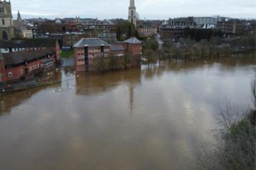
URGENT UPDATE: Flood warnings are now in effect across multiple areas in Worcestershire, including Worcester and Upton-upon-Severn, as the Environment Agency reports alarming rises in water levels. As of this afternoon, February 6, the River Severn has surged more than four feet in both North and South Worcester, prompting immediate action from local authorities.
Residents in North Worcester are specifically warned of potential flooding affecting properties and roads around Waterworks Road, Newport Street, and Pitchcroft Lane. In South Worcester, similar risks threaten areas including Quay Street, South Quay, Diglis Avenue, and Hood Street. A spokesperson for the Environment Agency stated, “Flooding is expected on February 6 and over the coming days.”
In Upton-upon-Severn and surrounding villages, flooding is anticipated to impact the A4104 bridge and Church Street, with additional risks to Hanley Castle and Saxons Lode. Furthermore, flood warnings have been issued for the River Avon in areas like Wyre Piddle, Strensham, and Bredon, where peak flooding is projected to occur this Sunday, February 8.
Several road closures are already in effect and are expected to last for the coming days, creating significant travel disruptions. The Met Office forecasts continued rainfall in Worcester until 9 PM today, with further rain expected to resume early tomorrow at 4 AM, lasting until 10 PM. Sustained rain is also predicted for the upcoming days, including Sunday, Tuesday, Wednesday, and Thursday.
Residents are urged to stay vigilant and monitor local updates as conditions evolve. With the threat of flooding looming, community safety remains a top priority. Those living in affected areas should prepare for possible evacuations and stay tuned to official announcements from the Environment Agency and local authorities.
As the situation develops, further updates will follow. Stay safe and informed.